Text
Information that describes objects, events or other features with a location on or near the surface of the ground, known as Geospatial data, is key to tracking how changes to the climate are affecting Vanuatu’s natural and built environment.
Vanuatu Government agencies rely on geospatial data like land surveys and maps to effectively measure the effects of climate change, and to plan future projects to ensure that they are resilient to climate change and extreme climate and weather events.
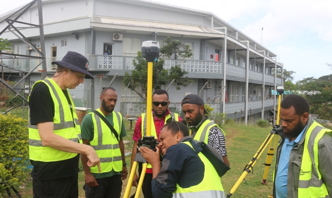
Representatives of Government agencies responsible for climate-sensitive sectors like infrastructure and water resources, as well as climatologists and forecasters from the Vanuatu Meteorological and Geohazards Department (VMGD) are now better equipped following a training workshop on gathering accurate geospatial data, last week. Ten staff from the Public Works Department (PWD), Department of Water Resources (DoWR) and VMGD received training on real-time kinematic positioning for global navigation satellite systems (RTK-GNSS).
RTK positioning is a technology that uses ground-based radio receivers, deployed by hand, to correct for errors in measurements received from global navigation satellites, when gathering geospatial data at a location. These errors are caused by fluctuations in the Earth’s atmosphere that affect the radio signals received from global navigation satellite systems by ground-based measuring instruments, such as GPS (Global Positioning System) devices. By using RTK positioning, it becomes possible to get up to centimetre-level accuracy when gathering geospatial data.
The three-day training event, held from 18-20 July at VMGD headquarters in Port Vila, covered technical topics relating to the setup of geospatial measuring equipment such as tripods, and ensuring correct settings for RTK devices. The training was provided by Mangoesmapping Pty Limited, an Australian Geographic Information Services company on behalf of the Vanuatu Klaemet Infomesen blong Redi, Adapt mo Protekt (VanKIRAP) Project.
Site Inspector for the Public Works Department’s Shefa Division, Mr Arty Iman, said “the RTK-GNSS training is invaluable for engineers, as collecting accurate data plays a crucial role in producing resilient designs that can mitigate the impacts of climate change for infrastructure projects.”
VMGD forecaster, Mr Iuma Bani, agrees.
“The training has been incredibly comprehensive, and the presenter’s expertise in the field has made the training both informative and engaging. I have learned valuable skills and knowledge that will greatly assist me in my work, particularly in hazard mapping. By applying the techniques taught in the training, I can accurately map areas affected by flooding and storm surges after cyclones,” he said. “In my work, maps are essential for verifying warning notifications, and improving the accuracy of future forecasts. Additionally, the knowledge I’ve gained can also be applied to hazard mapping for coastal erosion, coastal inundation, and volcanic ash. The RTK-GNSS training is a valuable instruction for achieving high level accuracy and improving the resilience of communities.”
The main facilitator of the training, Mr Alistair Hart, Owner and General Manager of Mangoesmapping Pty Ltd says the training program will equip Vanuatu government technicians with the knowledge they need to collect precisely-positioned geospatial information.
“The training also enables local professionals to monitor climate-related hazards, support climate monitoring initiatives, and oversee the construction and maintenance of vital infrastructure like roads, footpaths, and drainage systems,” he said.
“Working with the wonderful team at VanKIRAP has been an incredible experience. The people of Vanuatu are exceptionally friendly, which fills my heart with joy. Empowering the local community with newfound capacity has been gratifying, and I extend my heartfelt appreciation to the local team for their warm welcome. I am immensely grateful for this opportunity and eagerly look forward to future collaborations.”
This activity was coordinated by the Secretariat of the Pacific Regional Environment Programme (SPREP) together with the Vanuatu Government through the VanKIRAP Project.
The Vanuatu Klaemet Infomesen blong Redy, Adapt mo Protekt (VanKIRAP) Project supports climate-resilient development in Vanuatu by equipping decision-makers, communities, and individuals in Vanuatu with the climate information services (CIS) they need to respond to climate variability and change. Target audiences are Vanuatu’s agriculture, fisheries, tourism, infrastructure and water sectors, and the public. The Project is housed at VMGD, and jointly managed by VMGD and the Secretariat of the Pacific Regional Environment Programme (SPREP) with funding from the Green Climate Fund. NIWA is a VanKIRAP delivery partner.
For more information, please contact Mr. Sunny Kamuta Seuseu, VanKIRAP Acting Manager, at [email protected]
